Rebuilding FourSquare for ActivityPub using OpenStreetMap
By @edent![]() · ActivityPub fediverse FOURSQUARE geolocation OpenStreetMap · 30 comments · 750 words · read ~1,141 times.
· ActivityPub fediverse FOURSQUARE geolocation OpenStreetMap · 30 comments · 750 words · read ~1,141 times.
I used to like the original FourSquare. The "mayor" stuff was a bit silly, and my friends never left that many reviews, but I loved being able to signal to my friends "I am at this cool museum" or "We're at this pub if you want to meet" or "Spending the day at the park".
So, is there a way to recreate that early Web 2.0 experience with open data and ActivityPub? Let's find out!
This quest is divided into two parts.
- Get nearby "Points of Interest" (POI) from OpenStreetMap.
- Share a location on the Fediverse.
OpenStreetMap API
OpenStreetMap is the Wikipedia of maps. It is a freely available resource which anyone can edit (if they're skilled enough).
It also comes with a pretty decent API for querying things. For example, nw["amenity"]({{bbox}}); finds all "amenities" near a specific location.
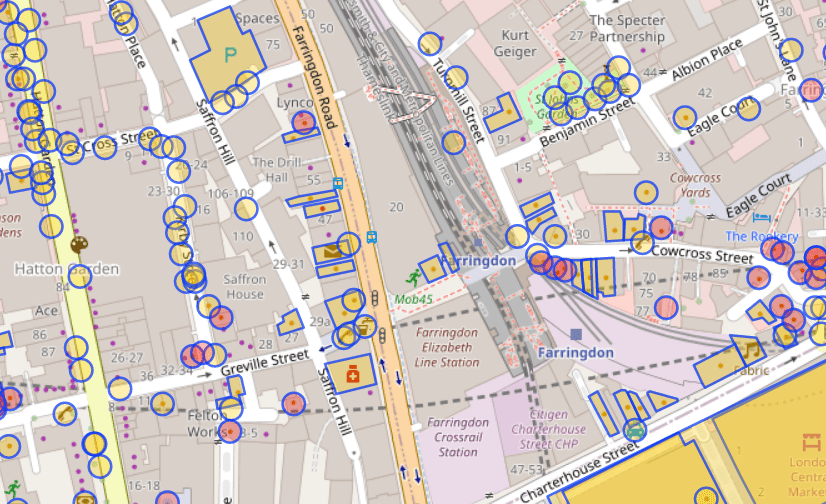
As you can see, it has highlighted some useful areas - a pharmacy and a pub. But it has ignored other useful locations - the train station and the park. It has also included some things that we may not want - bike parking and a taxi rank.
What API call is needed to get useful locations of of OverPass?
It's possible to specify the type of thing to find using nw["amenity"="restaurant"]; - but adding every single type of thing would quickly end up with a very large query containing hundreds of types.
It is also possible to exclude specific types of places. This retrieves all amenities except for fast food joints:
nw["amenity"]({{bbox}});
-
nw["amenity"="fast_food"]({{bbox}});
Again, that would be complex.
Perhaps one solution is just to return everything and let the user decide if they want to check in to a telephone kiosk or a fire hydrant? That's a bit user-hostile.
Instead, this query returns everything which has a name nw["name"]({{bbox}});

That cuts out any unnamed things - like park benches and car-sharing spots. But it does add named roads and train lines.
It is possible to use filters to exclude results from OverPass. The best that I can come up with is: nw["name"][!"highway"][!"railway"][!"waterway"][!"power"]({{bbox}});
That gets everything which has a name, but isn't a highway or railway or waterway or powerline. It isn't perfect - but it will do!
This is the query which will retrieve the 25 nearest things within 100 metres of a specific latitude and longitude. It includes the name and any other tags, the location, and the OSM ID.
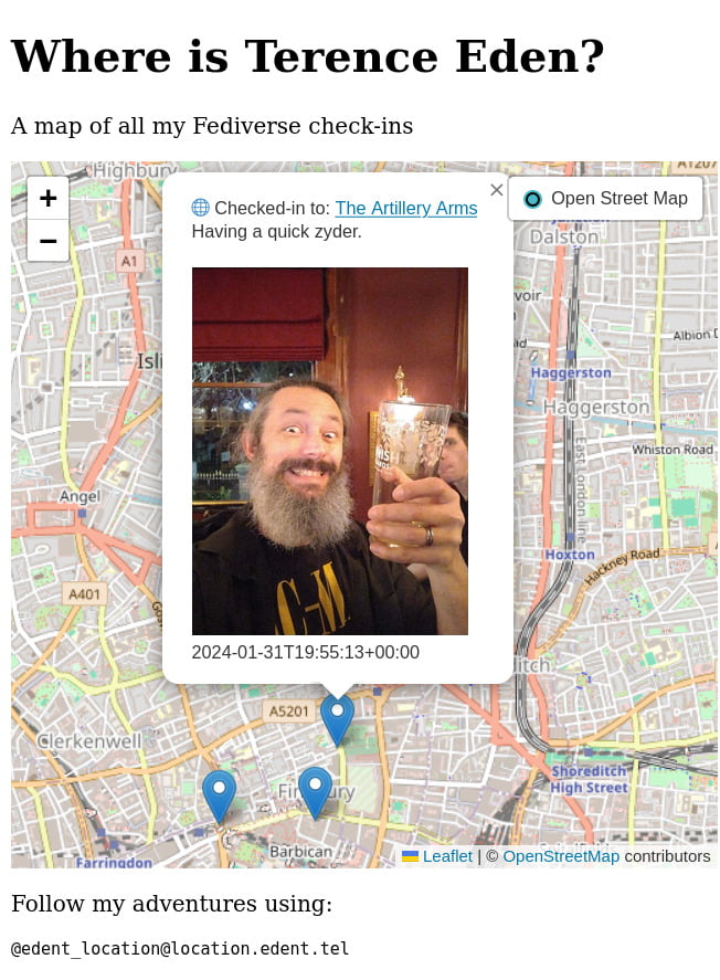
ActivityPub
There's good news and bad news here. Firstly, ActivityStreams (which are subscribed to in ActivityPub) supports the concept of "Place" and "Location".
Once the user has a latitude and longitude, the can share it - along with a message, photo, or anything else.
Something like:
{

    "@context": "https://www.w3.org/ns/activitystreams",

    "type": "Note",

    "content": "Here in NYC! <a href=\"https://www.openstreetmap.org/way/958999496\">John Lennon's Imagine Mosaic</a>.",

    "attachment": [

        {

            "type": "Image",

            "mediaType": "image\/jpeg",

            "url": "https:\/\/fastly.4sqi.net\/img\/general\/590x786\/56367_9pxuZJD7d1hgPdaMFcFq1pipvTTMynBJsYcpHH-b8mU.jpg",

            "name": "A photo of a mosaic which says 'Imagine'."

        }

    ],

    "location": {

        "name": "John Lennon's Imagine",

        "type": "Place",

        "longitude": 40.77563,

        "latitude": -73.97474

    }

}
For example, here's a PixelFed post with an attached location - and this is the JSON representation. That status can be reposted into other social networks.
It is worth noting that Mastodon doesn't (natively) support location - if you view my repost of that PixelFed post you'll see there's no location metadata attached. That's OK! It just means that the status needs to include human-readable data.
Similarly, Mastodon doesn't support the arrive vocabulary. So this will be limited to a message with a location attached.
Other ActivityPub services do support location.
Putting it all together
Well… that's a job for next week. Probably!
- Building a web site which gets the user's location is easy.
- Getting the data from OverPass should be straightforward.
- Creating an ActivityPub server which can post geotagged notes into the Fediverse might be a little beyond my skillset! Some testing with Darius Kazemi's AP Glitch suggests this should work.
If you'd like to help, please leave a comment.

I loved foursquare and it was a shame when they changed the app beyond recognition to chase VC money.
I would definitely use something like this.. Pity the mastodon server won't accept it directly.. that limits its spread IMO (if all I needed was a frontend app connecting to a mastodon account, that's a much lower barrier to entry).
@Edent I liked the mayor stuff. I was mayor of lots of places here in #lapalma 😉
lapalma
@blog
#Friendica also allows you to add a #geolocation to a post (but not to a comment).
@blog I’d like to help with this in some way.
@Edent great stuff! i’d been wondering if such a service was possible with ActivityPub! very keen to see how it progresses. if i can assist with testing or anything, let me know.
@Edent yes!!! I can’t find the thread now but I was discussing this exact idea with… I think it was @tijs and @zverik a few months ago. I have no dev time to devote for it now but happy to chat if you’d like to swap ideas.
In particular, I think one raison d’être for such an app (aside the obvious utility which obviously many of us got from 4sq) is to gamify submitting and verifying POIs in OSM. With a good UX and some careful thought, I’m optimistic it could really improve OSM for POIs.
@Edent love this idea! I was a big fan of Foursquare back in the day.
I maybe able to help with the Overpass query, except you don't actually say what the "useful locations" actually are. listing "every single type of thing" that you want, is probably the only way to do it.
if that is actually what you need though. Wouldn't a flag/marker be just as good? For instance, parks can be pretty large & a supplying a specific point would be more convenient.
This is very much dependent on user needs. For some people, it's enough to say "I'm at the train station", but others might want to say "I'm on Platform 7".
For me, it is important to have a human-readable location. So that might be a statue in a park, but it is unlikely to be a specific tree.
Suggestions welcome for how to structure that query!
[bbox:{{bbox}}];//global boundary only needs to be called once
wr[leisure=park]->.Park; //All parks in the area store in .Parks variable
(
// Searches for the various types of statues within each Park.
nw(area.Park)[historic=memorial][memorial=statue];
nw(area.Park)[tourism=artwork][artwork_type=statue];
);
out meta center; //output as a POI
https://overpass-turbo.eu/s/1GzP
Find out how real world objects are tagged in OSM I find it best to use this tool:
https://taginfo.openstreetmap.org/search?q=statue#values
As I pointed out in the blog post, it is difficult to build up a list of every tag that a user might possibly want to check in to. New tags are added all the time, so it becomes impossible to keep up.
So that's why I'm just going for things which have names, but aren't streets.
@james @blog
You're probably thinking of https://untappd.com/user/edent
That is pretty good at picking out pubs and bars.
@Edent the mayor thing was a tactic to help with onboarding when in a small sparse network 🙂
Interesting to see this project's outcome.
@Edent I'm hooked, waiting for the next post! (no pressure on the timing though). I'm new to the OSM space, so Overpass didn't make sense for quite some time, till I searched for it online.
@Edent I loved the integration with my calendar, so that after I can find back where that place was where I was last year
@Edent microformats know this as well. I toyed with this for my blog but finding a reliable map provider (without cookies) turned out to be quite difficult.
I even tried setting up my own tile server for osm one day. The result was: Don't.
@Edent so, I strongly recommend looking at the full Activity Vocabulary. There are several activities specifically for check-ins. I'm excited about this project.
@Terence Eden Just FYI: At least Hubzilla has the built-in functionality to add a geographic location to each post, and you can optionally even enter a default location into your channel settings. There's an optional app named OpenStreetMap that can show the post location or any other place in OSM. There's also an optional app named Rendez-vous that can be used to plan meetings using OSM as the map provider.
Both Friendica and (streams) have similar OpenStreetMap add-ons, but they don't have anything like Rendez-vous.
Granted, it all dates back to before Mastodon, so it isn't geared towards working with Mastodon. Also, it isn't built against ActivityPub primarily but against DFRN (Friendica), Zot6 (Mastodon) and Nomad ((streams)). But maybe it's worth checking out.
#Long #LongPost #CWLong #CWLongPost #FediMeta #FediverseMeta #CWFediMeta #CWFediverseMeta #Friendica #Hubzilla #Streams #(streams) #OpenStreetMap
@Edent I've noodled around with trying to write some code to turn all of OSM into a Foursquare-style venues database but haven't had the time.
My rough plan—a script that parses the entire OSM dataset and:
- flattens ways/relations into points (calculate centroids)
- emits lat, long, label, OSM type+ID
Stick result in DB (SQLite+SpatiaLite appeals to me), index on coords, query N closest.
@blog I loved the old FourSquare too. On multiple occasions it led to an impromptu beer with a mate or a discovery of a nifty cafe.
A particular habit used to be avoiding rush hour traffic with a couple of drinks, for which I’d always check FourSquare to see who else was hiding from the rush and go join them.
If I can help out, happy to pitch in.
@blog As maker of https://mapcomplete.org, a 'checkin here' button would be cool to add!
@blog This is an amazing idea!
This is what the "Unix philosophy" should mean: tools that give us easy access through APIs so we can easily combine them into novel applications.
Combining OSM map data with Fediverse location sharing is such a thing, and would be impossible with only closed-off proprietary software.
#FreeSoftware #OpenStreetMap
@blog Yesterday, I read this post from @aaronofsfo https://aaronland.info/weblog/2024/04/26/matrix/#usf
Today, I'm wondering how to convince my local museum to do the same thing, but to connect artifacts with actual locations in town (e.g., homes of local pioneers). Then connect the content from our local historians who do walking tours, or other media, for a self-guided immersive history experience. A local pizza place is supposedly haunted and there are tunnels underneath - would make for interesting browsing over a few beers, eh?
I imagine that the museum would be its own instance. But how would you implement something to ask the museum "what's the history of this spot where I'm standing?"
And then, I want to push the set of OSM locations that the museum selects to a bike navigation tool for a self-guided biking tour (with free beer when I find all the spots!). "What's nearby?"
https://www.bikepointz.com/app
https://wandrer.earth/
@footsteps @blog @aaronofsfo we're working on it – https://millsfield.sfomuseum.org/blog/tags/wayfinding/
More comments on Mastodon.