
I feel terribly guilty when I visit a new city, post photos of my travels, only to have a friend say "Hey! Why didn't you let me know you were in my neck of the woods?" Similarly, if I bump into an old acquaintance at a conference, we both tend to say "If only I'd known you were here, we could have had dinner together last night!" I do enjoy the serendipity of events like FOSDEM - randomly…
Continue reading →
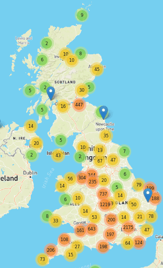
My wife and I run OpenBenches. It's a niche little site which lets people share photos of memorial benches and their locations. Most modern phones embed a geolocation within the photo's metadata, so we use that information to put the photos on a map. Google's Android has now broken that. On the web, we used to use: <input type="file" accept="image/jpeg"> That opened the phone's photo picker…
Continue reading →

My wife and I run OpenBenches - a crowd-sourced database of nearly 40,000 memorial benches. Every bench is geo-tagged with a latitude and longitude. But how do you go from a string of digits to something human readable? How do I turn -33.755780,150.603769 into "42 Wallaby Way, Sydney, Australia"? Luckily, that's a (somewhat) solved problem. Services like OpenCage, StadiaMaps, OpenStreetMap,…
Continue reading →

I used to like the original FourSquare. The "mayor" stuff was a bit silly, and my friends never left that many reviews, but I loved being able to signal to my friends "I am at this cool museum" or "We're at this pub if you want to meet" or "Spending the day at the park". So, is there a way to recreate that early Web 2.0 experience with open data and ActivityPub? Let's find out! This quest is…
Continue reading →
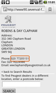
Peugeot's new mobile advert has a couple of critical flaws - but has just enough innovation to redeem it in my eyes. Read on to find the two basic mistakes they made, how to solve them, and the cool feature you should be incorporating into your adverts. (more…) …
Continue reading →

As part of my project to create a mobile polling station locator site, I've been playing with various mapping APIs. As a base experiment, I passed the postcode of a polling station (GU22 7DT) to both Google Maps and Yahoo Maps. Here are the results. - Two things of interest to note. Firstly, Google has a specific "Mobile" call in the API, it reformats the map image to be more readable on…
Continue reading →