When Liz and I created the OpenBenches website, it was just designed to be a fun way for people to record memorial benches. Since then things have got out of hand and we now have over thirty-nine thousand benches recorded!
Our plan was never to compete with something like OpenStreetMap. The OSM project is vast, complex, and brilliant - we are small, simple, and differently brilliant. But, over the years, people have repeatedly asked if there's any way to combine the two data sets.
This has proved logistically complex for several reasons.
- Our users aren't experienced mappers.
- Most of our entries are uploaded with fairly fuzzy GPS co-ordinates. Mobile phones aren't always the best at accurate locations and, besides, people tend to stand away from the bench when taking its photo. So our data isn't quite at the level of quality rightly demanded by OSM.
- OSM didn't have a tag specifically for memorial benches.
- We started out site in 2017. OSM
added the
Tag:memorial=benchin 2021 . Up until then, there wasn't a great way to record that a bench was a memorial.
- We started out site in 2017. OSM
added the
- Data licencing is complicated.
- We chose the Creative Commons Attribution ShareAlike licence - it seemed like a good idea at the time! OSM use ODbL which is subtly incompatible. As such, OSM volunteers asked us to sign a waiver so they could use the data - which we happily did.
- Adding or editing data on OSM can be complicated.
- OpenBenches is designed to be an upload-and-forget process. It doesn't matter much to us if a bench is recorded a dozen metres away from its true location. But that isn't the way OSM works. We didn't want to bulk upload data which was inaccurate, incomplete, or inappropriate. Luckily, there are now tools to help with that!
Things have been working away in the background. Some people have manually added Key:openbenches:id to appropriate benches, and others have edited our database to make the locations closer to reality.
And now, thanks to the sterling work of the brilliant Pieter Vander Vennet we're moving to our next phase of increased collaboration!
Firstly, there are about 1,060 benches on OpenStreetMap which have an OpenBenches ID. I've taken all those OSM IDs and put them into our database. Which means that the OpenBenches website can display a button like this:

One click and you're looking at OSM - ready to investigate, edit, or admire.
But what about the other 38,000 benches? Well, that's where MapComplete comes in. MapComplete is sort of like Pokémon Go for maps. As you wander this Earth, you can complete little quests to help improve OpenStreetMap. For example, on the "Pubs" quest, you can add details of all the pubs you visit.
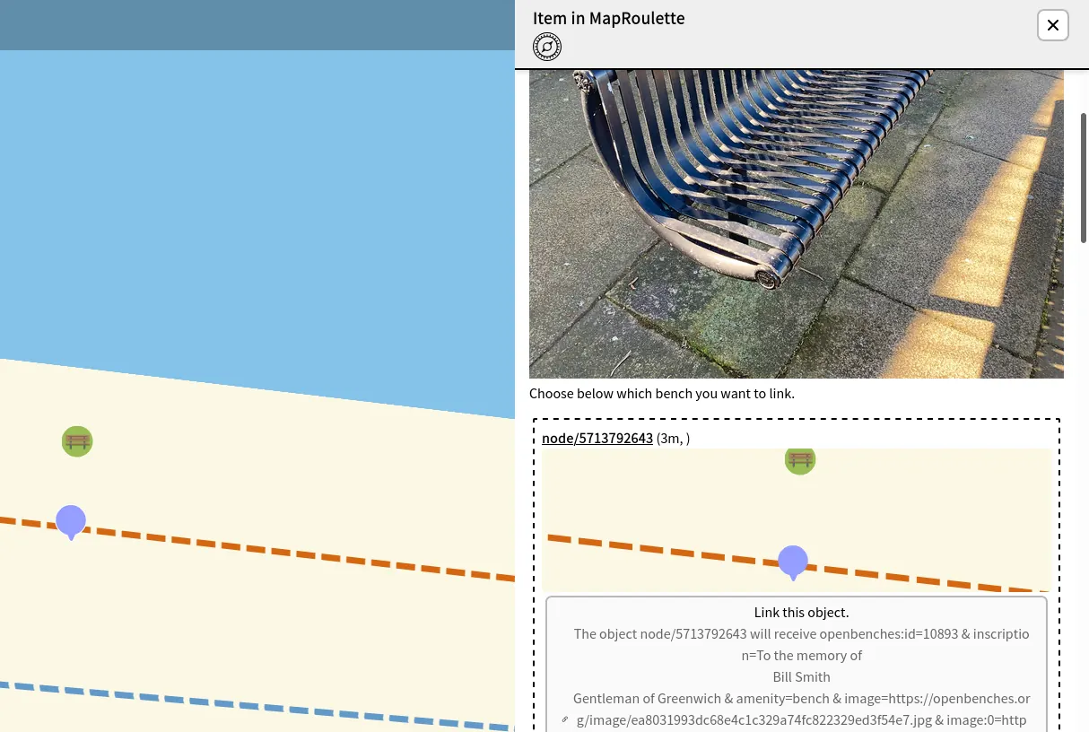
With the "Bench" quest, it is a little different. If an OpenBench is sufficiently nearby an OSM bench, you'll get the option to link the two with a couple of clicks.
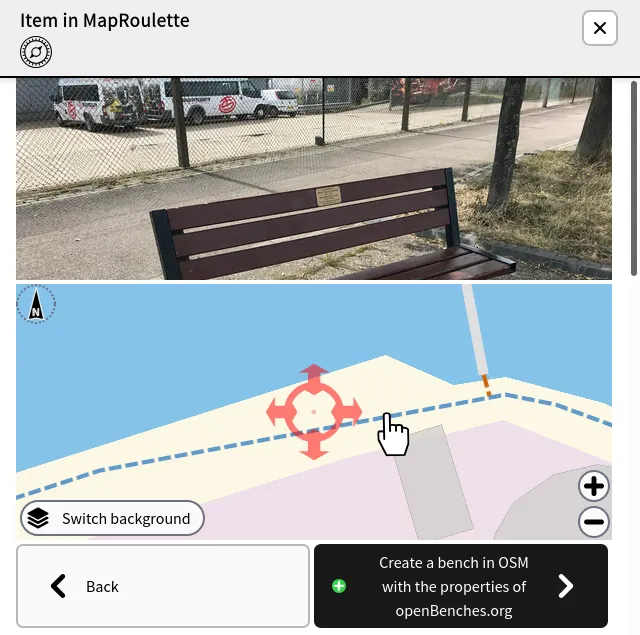
But there are loads of benches we have discovered which aren't in the OSM database. In which case, you can add a new bench to OSM using the data from OpenBenches!
This has been a couple of years in the making - but it looks like most of the kinks are now sorted out. I'm sure there will be a few early problems, and no doubt a bit of late-night bug fixing, but I hope that this is the start of something long-lasting. The joy of decentralised sites using open data is that we can all build on each others' work in a spirit of fun and exploration.
4 thoughts on “OpenBenches 💖 OpenStreetMap”
@Edent This is just really bloody lovely.
| Reply to original comment on tilde.zone
@Edent great to see and a good example for similar projects
| Reply to original comment on cosocial.ca
@Edent Very cool update! Love following this project along!
| Reply to original comment on stefanbohacek.online
@Edent That's two OB posts that have made me smile today (the other one was the plaque to a plaque)!
Nice work, everyone. Keep it up, it's lovely to have an outcome like this.
| Reply to original comment on cyberplace.social
More comments on Mastodon.